Details for: Kamp-Thaya-March-Bike Route
Brief description
Escape from the Danube and bike on a discovery of Lower Austria along the Kamp-Thaya-March cycling route; one of the most beautifulcycling routes in Austria.
The attractive bike route, in the north-eastern part of Austria, follows three Rivers and in contrast permeates the Wald- and Weinviertel - two romantic Regions on the border to the Czech Republic. Scenic diversity, clever signs, friendly and helpful people and high recreational value - the German magazine "active cycling" describes the Kamp-Thaya March cycle path (KTM) as excellent.
With four stars and the label "Very recommended" did the editorial staff describe the 400 km long route from Krems an der Donau through Wald- and Weinviertel in the vast landscape of the March to Vienna through a largely undiscovered cycling region beyond main roads and mass tourism. Peace, tranquility and idyllic scenery make this trip an experience. The stages with a length between 30 and 55 km can be varied, while the busiest routes are mainly confined to the Waldviertel. Thanks to the perfect KTM route guide the orientation on the route is easy. On the route, wheel-friendly restaurants and accommodation facilities are included.
Wild nature, deserted villages, medieval castles and cultivated wine make the tour an unforgettable experience on the most beautiful detour from Krems to Vienna.
Description
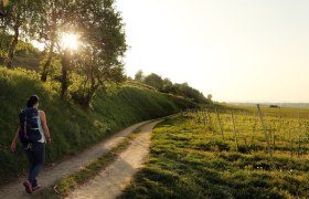
At the beginning of the tour, you can enjoy beautiful cycling along the Kamp (river), then you can expect steep sections in the Waldviertel. Go through the Weinviertel mostly downwards as the route continues through the soft hilly landscape to reach the Danube. The route is largely on traffic-free freight routes and secondary roads. The line in the Waldviertel is mostly paved, however in the Weinviertel you can also encounter gravel paths. The Kamp-Thaya March cycle path is consistently well signposted. Along the way you can encounter also road signs to the smaller regional round tours (such as the Teich-Tümpel-Tour) and to tours which are named after grape sorts (e.g. Welschriesling). Information about the smaller tours are found in the Weinviertel OST and Weinviertel West maps. On the line a variety of destinations are also offered, such as the Loisium wine world, Schloss Rosenburg, Stift (abbey) Zwettl, National Park Thayatal, Retzer Wine Cellar, Therme (thermal springs) Laa, wine experience world Poysdorf, Schloss Hof (castle) and more.
Starting point of the tour
Krems
Destination point of the tour
Stopfenreuth
Route description Kamp-Thaya-March-Bike Route
Length: 422 km
Description: Varied cycling along three rivers; physically stimulating with some heavy gradients in the Waldviertel; in the Weinviertel the route goes down mostly, then through soft hilly landscapes around Retz and Laa/Thaya to Marchegg. The route is at least a week's tour or longer to plan (e.g. for culinary discovery trips or tours by the nostalgia train and bike into the Thayatal (Valley), the smallest national park in Austria). Highlights along the route: the wine world Loisium in Langenlois, the Renaissance Castle Rosenburg, the Stift (abbey) in Altenburg, Zwettl and Geras, the Retzer experience cellar or the Therme (thermal springs) Laa.
ÖBB Nordanbindung von Hohenau/ March bis nach Angern/ March
Author's tip
Stage proposals:
The 420 km long cycle path can be divided into smaller stages. This way the routes are easily cycled.
Section Kamptal: Krems Gars/Kamp - Horn, length: 54 km
Section castles in the Waldviertel: Waidhofen/Thaya - Raab, length: 50 km
Section National Park Thayatal: Raab - Riegersburg - Retz, length: 55 km
Section Kellergassen: Retz - Haugsdorf - LAA / Thaya, length: 50 km
Section Weinviertel: LAA/Thaya - Hohenau, length: 65 km
Section Hohenau - Dürnkrut - Marchegg Length: 62 km


